Symbianize Forum

Most of our features and services are available only to members, so we encourage you to login or register a new account. Registration is free, fast and simple. You only need to provide a valid email. Being a member you'll gain access to all member forums and features, post a message to ask question or provide answer, and share or find resources related to mobile phones, tablets, computers, game consoles, and multimedia.

All that and more, so what are you waiting for, click the register button and join us now! Ito ang website na ginawa ng pinoy para sa pinoy!

GIS (Graphic Information System) Mapper - Requests

Hi Sir, parang mali po definition mo sa GIS..its Geographic Information System po..i'm a GIS enthusiast at ArcGIS 10.1 gamit ko ngayon for work..f may question po kayo o need nyo po ng tulong, pwede nyo po ako i.pm..thanks

hi.. sir baka po may alam kayo ng training center dito sa pinas.. need ko lang po matuto at ma explore ang gis. autocad draftsman po ako at willing matuto ng arcgis.. salamat po
 
ARCGIS 10.1 din gamit ko sa ofis.. recently nagtraining kami sa UP Diliman at nung gumagawa kami ng CLUP namin.. maganda talaga ang GIS. i suggest mag start ka muna sa QGIS bago mag ARC.. suggestion ko lang naman po.. by the way, nice thread!:thumbsup:
 
sino willing magturo sa ganito ..willing ako magbayad ..need ko lang matuto
pm me sa gusto magturo sa akin.at pata mapag uusapan kung magkano ang PF nya
 
Mas mabuting matutunan nyo boss ang ARCGIS mas advance kasi sya, yan ginagamit namin dito sa Department of Environment and Natural Resources (DENR) Biodiversity Management Bureau (BMB), maraming tutorial sa youtube si ARCGIS. kung gusto nyo ng training center mas maigi sa NAMRIA kau magapply dahil mas marami silang alam sa mapping at may certification sila sa mga nakakatpos ng training course
 
May gumagamit po ba ng SAS planet dito, pano po ayusin yung "Unknown status code 429" tia.
 
mga sir gusto ko sana matuto ng GIS, may advice ba kayo? thanks:praise:
 
boss baka naman may manifold software ka. pwede pashare? tnx much
 
Hi Sir, parang mali po definition mo sa GIS..its Geographic Information System po..i'm a GIS enthusiast at ArcGIS 10.1 gamit ko ngayon for work..f may question po kayo o need nyo po ng tulong, pwede nyo po ako i.pm..thanks

Sir baka may tutorial ka pashare naman minsan din inutusan ako nyan for work sabi ko d ko alam.. pahingi din po ng installer..
 
Mga sir. Mapper din po ako. Yung pinagkukunan ko dati ng mga shapefiles na philgis.org an unaccessible na po. San po kaya ako pwedeng magdl ng mga shapefiles ng mangrove area at forest land dito sa Pilipinas.
 
gis user din ako. gamit ko 12.1. mas maganda sana kung may mag post ng tutorial from beginning hanggang makagawa kana ng 3d... at mga installer din. kung pano mag dem or etc...

Bigyan mo ako ng copy ng ARCGIS 12.1...ituturo ko mula ARCGIS 9.0...matagal na ako trabahong ito...
 
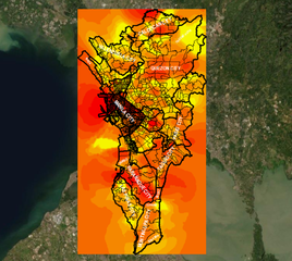
View attachment 381571

Ito yung real time ng COVID 19 Analytics Map using GIS application (-) (+) po yan...kung susunod tayo sa Batas mag negative po yan...pero pagmagmatigas tayo ng ulo mas lalong lumala pa ang sitwasyon...data gathered last 25 May 2020....
 

Attachments

  • MM1 as 22 May 2020.png
    MM1 as 22 May 2020.png
    759.8 KB · Views: 19
Mga sir. Mapper din po ako. Yung pinagkukunan ko dati ng mga shapefiles na philgis.org an unaccessible na po. San po kaya ako pwedeng magdl ng mga shapefiles ng mangrove area at forest land dito sa Pilipinas.
bos mag request ka na lang ng shapfiles sa mga cnero office mas accurate cla kc nagaground nila karamihan
Post automatically merged:

bos mag request ka na lang ng shapfiles sa mga cnero office mas accurate cla kc nagaground nila karamihan
bos mag request ka na lang ng shapfiles sa mga cenro office mas accurate cla kc nagaground nila karamihan
 
Paturo po paano yung mga BLLM
 
Plot ng Lote ?
Post automatically merged:

Need Technical Description at tiepoint coordinates
 
Plot ng Lote ?
Post automatically merged:

Need Technical Description at tiepoint coordinates
yes sir yung sa mga Lote ng meron BLLM gusto ko sana yung malaman ano equivalent sa latitude longitude para ma plot sa QGIS
 
May gumagamit po ba ng SAS planet dito, pano po ayusin yung "Unknown status code 429" tia.
change m sir ang number sa google
Post automatically merged:

yes sir yung sa mga Lote ng meron BLLM gusto ko sana yung malaman ano equivalent sa latitude longitude para ma plot sa QGIS
depende yan sir sa area, kasi every city or municipality may sets of MBM BBM at BLLM
BLLM kadalsan nasa title, makukuha ka ng copy ng coordinates sa mga surveryor (excel or cad file)
 
Back
Top Bottom