Symbianize Forum

Most of our features and services are available only to members, so we encourage you to login or register a new account. Registration is free, fast and simple. You only need to provide a valid email. Being a member you'll gain access to all member forums and features, post a message to ask question or provide answer, and share or find resources related to mobile phones, tablets, computers, game consoles, and multimedia.

All that and more, so what are you waiting for, click the register button and join us now! Ito ang website na ginawa ng pinoy para sa pinoy!

Earthwatch: Because....

Stormer0628

Symbianize Angel
Advanced Member
Messages
2,145
Reaction score
5
Points
28
attachment.php


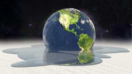
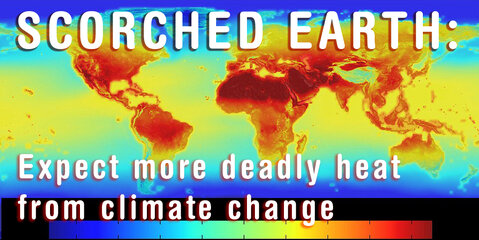
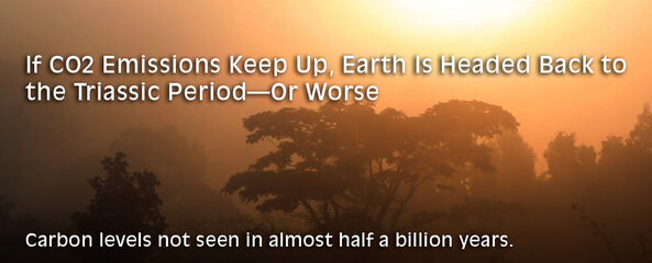
While science piles up astounding new findings almost everyday, underneath us the Earth is threatening to pull the rug off our feet any moment, making all these achievements that make our current civilization stand out from all the rest under threat of ending up all for naught.

The threat of cataclysmic climate is beyond dispute. If you think otherwise, watch this thread for the mounting evidence to the fact, Trump and his kind notwithstanding.

And no—that this thread starts on Earth Day is mere coincidence. Let's just say all the half-cooked ideas and procrastination contrived to end here.... :lol:

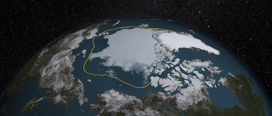
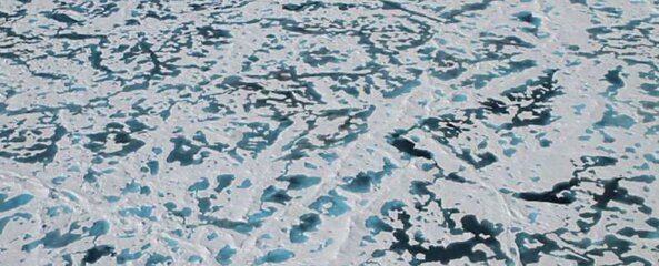
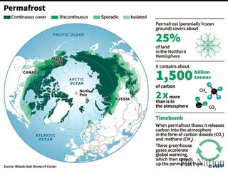
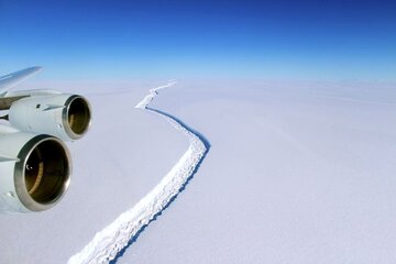
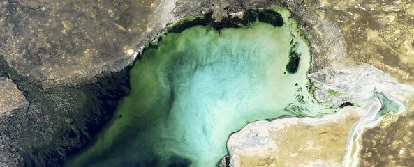
Anyway, since perhaps it's the headlines of late that finally prompted this, let's start with what's happening up there in the Arctic, encompassing such areas as the North Pole, Siberia, Russia, Greenland, Canada, the US....


7,000 Huge Gas Bubbles Have Formed Under Siberia, and Could Explode at Any Moment

What happens when the permafrost thaws.


attachment.php


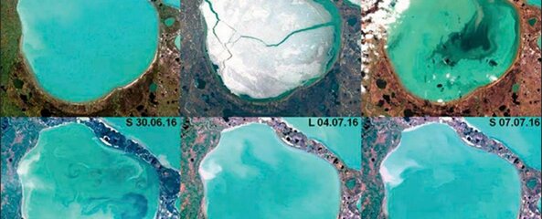
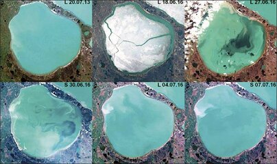
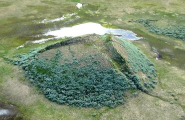
Last year, researchers in Siberia's remote Bely Island made the bizarre discovery that the ground had started bubbling in certain places, and was squishy under the locals' feet like jelly.

At the time, just 15 of these swollen bubbles had been identified, but an investigation in the wider region of the Yamal and Gydan peninsulas has revealed that 7,000 or so of them have cropped up, and the concern now is that they could explode at any moment.

"At first, such a bump is a bubble, or 'bulgunyakh' in the local Yakut language," Alexey Titovsky, director of the Yamal Department for Science and Innovation, told The Siberia Times.

"With time, the bubble explodes, releasing gas. This is how gigantic funnels form."

Those gigantic funnels Titovsky is referring to are every bit as intimidating as they sound.

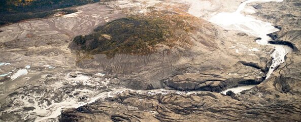
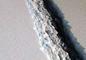
While collapsed bubbles can form fairly small 'pockmarks' in the ground, they've also been linked to the massive sinkholes and craters that have been appearing across Siberia:


Now picture thousands of these death traps dotted across the landscape, with each of the 7,000 newly identified bubbles poised to explode without warning.

So what exactly is going on here?

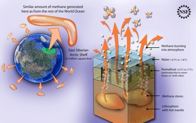
Back in 2016, local environmental researchers Alexander Sokolov and Dorothee Ehrich decided to pull back the dirt and grass that had been blanketing these bulging bumps of earth, and found that the air escaping from them contained up to 1,000 times more methane than the surrounding air, and 25 times more carbon dioxide.

And things can get even weirder at the bottom of the biggest sinkholes—a 2014 investigation into a 30-metre-wide (98-foot) crater on the Yamal Peninsula found that air near the bottom of the crater contained unusually high concentrations of methane—up to 9.6 percent.

As Katia Moskvitch reported for Nature at the time, archaeologist Andrei Plekhanov from the Scientific Centre of Arctic Studies in Salekhard, Russia, told her that the surrounding air usually contains just 0.000179 percent methane.

Researchers have hypothesised that these methane bubbles are linked to a recent heatwave that had prompted the Siberian tundra's permafrost to thaw.

Siberia's permafrost has become famous for its ability to keep things perfectly preserved for thousands of years, such as this amazing 12,400-year-old puppy,or these adorable lion cubs, which still had their tawny fur coats on after 30,000 years.

A 2013 study found that a global temperature rise of 1.5°C would be enough to kickstart an unprecedented period of melting, but thanks to abnormally hot summers linked to climate change, local researchers suspect that this is already starting to occur, with daily temperatures in July 2016 hitting a worrying 35°C (95°F).

"Their appearance at such high latitudes is most likely linked to thawing permafrost, which in is in turn linked to overall rise of temperature on the north of Eurasia during last several decades," a spokesperson for the Ural branch of Russian Academy of Science told The Siberian Times.

We're still waiting on some peer-reviewed research to come from these investigations so we can know more about the evidence scientists are using to link methane bubbles to climate change, but it looks like the unique geology that makes up the Siberian tundra also plays a big role in the phenomenon.

According to Vasily Bogoyavlensky from the Russian Academy of Sciences, who has been studying these bubbles for years now, the earth here has been dated to the Cenomanian era of the Late Cretaceous epoch (100.5 to 93.9 million years ago) and has been identified as an ancient, shallow gas reservoir, situated just 500 to 1,200 metres (1,640 to 3,937 feet) below the surface.

"Gas rising to the surface through the systems of faults and cracks causes overpressure in the palaeo-permafrost clay layers, and breaks through the weakened parts of it, forming the gas springs and blowout craters," Bogoyavlensky wrote in a 2015 edition of GEO ExPro magazine.

"Basically, after a long period of growth, the upper part of the 'pingo' (the soil covering the ice core) cracks, and the ice core melts, forming a round lake. It is known that sometimes these ice mounds explode under excessive ice pressure."

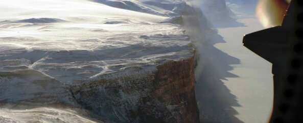
Here's an image of one bubble found by Bogoyavlensky that has swelled immensely:


attachment.php


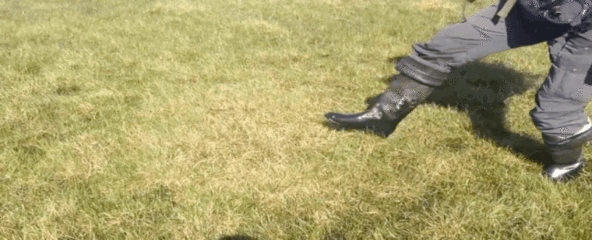
And here's what it looks like if you find one small enough to step on:


The good news is that through all of this, there are several research teams out on the tundra studying this weird phenomenon, so hopefully we'll have some definitive answers soon.

To reiterate what we said earlier, published research on these bubbles is still forthcoming, and Titovsky in particular says he's not done with his field investigation yet, so we'll have to take these conclusions with a grain of salt until the results are verified.

But the priority right now is for researchers to identify which bubbles pose a threat to the locals, and provide a map highlighting the potential explosion 'hot spots'.

"We need to know which bumps are dangerous and which are not," Titovsky toldThe Siberian Times.

"Scientists are working on detecting and structuring signs of potential threat, like the maximum height of a bump and pressure that the earth can withstand. Work will continue all through 2017."

SOURCE


UPDATED: VIDEO OF EARTH with NASA'S rendition of "Sound of Silence"
 

Attachments

  • Earthwatch.jpg
    Earthwatch.jpg
    448.8 KB · Views: 1,085
  • output_kP1rbT.gif
    output_kP1rbT.gif
    2 MB · Views: 1,146
  • bubble-march.jpg
    bubble-march.jpg
    118.7 KB · Views: 1,057
Last edited:
....


More Than 200 Bright Blue Arctic Lakes
Have Started Bubbling With Methane Gas


attachment.php


Satellite images have revealed more than 200 strange, bright blue lakes in Russia's Arctic regions that are bubbling "like jacuzzis" as a result of leaking methane gas.

The lakes are a type of thermokarst lake, which form when thawing permafrost causes the surface to collapse and fill in with meltwater. But unlike normal, dark thermokarst lakes, these ones are bright blue and bubbling, because of methane that's leaking into them before escaping into the atmosphere.

According to Vasily Bogoyavlensky from the Russian Academy of Sciences, these newly identified thermokarst lakes appear near oil and gas deposits on the Yamal and Gydan peninsulas in Siberia.

Their bright blue color is a result of algae that's attracted to the high sulfur levels caused by the leaking methane.

You can see the surface of one of these lakes between 2013 and 2016 as photographed by the Landsat-8 and Sentinel-2 satellites:


attachment.php

"These lakes have a number of features, which can help identify them from a distance," Bogoyavlensky told the Siberian Times.

"The anomalous blue color of water, the presence of craters on the bottom and gas seeps in the water, the traces of gas in the seasonal ice cover, as well as active coastal erosion and permafrost swelling near the water's edge."

Bogoyavlensky and his team identified the strange new lakes after studying satellite data from 2015 and 16, and are now monitoring them as an active source of methane emissions.

They appear to be similar to pockmarks and craters found on the floors of some of the world's oceans, which are also known to be slowly leaking methane stores.

Siberia is no stranger to thermokarsts—Siberia's massive hole known as the 'Doorway to the Underworld' is one of these craters that's now become so large that it's unearthed entire ancient forests.

But researchers hadn't seen anything like these lakes in the region before.

They aren't entirely sure what's causing them, but the hypothesis for now is that it could be related to seismic activity.

"For example, over one of the gas deposits (in Yamal), lakes are located along two lines ... looking like a giant cross," Bogoyavlensky told the Siberian Times.

This suggests "genetic connection of craters with deep faults in the Earth's crust, but to confirm we need to conduct thorough seismic research.”

What's interesting is that the satellite data suggests the leaks are happening year-round in these regions, even at temperatures close to 0°C (32°F).

You can see lakes in the region of the Bovanenkovo and Kruzenshternskoye gas fields in the Landsat-8 images below (the left is visible colors, the right is an infrared image).


attachment.php

The research is ongoing, so it hasn't yet been published in a peer-reviewed journal—until that happens, we can't say for sure what's going on with these weird blue lakes.

But hopefully as experiments in the region continues, scientists will begin to get a better idea of what's going on.

And that's important, seeing as methane is roughly 30 times more potent than CO2 as a heat-trapping gas—and there's no shortage of it frozen beneath the Siberian trundra.

One study estimated that by 2100, up to 205 billion tonnes of carbon emissions will be released by permafrost if climate change continues to intensify, as Sarah Emerson reports for Motherboard.

The discovery of the lakes comes the same week as researchers announced that they're closely monitoring around 7,000 gas bubbles or 'pingos', which have formed in Siberia and are at risk of exploding to form huge craters.

Previous research had suggested that a global temperature rise of 1.5°C (2.7°F) would be enough to start the melting of Siberia's permafrost, and scientists are concerned that these lakes and pingos are a sign it's already happening.

Marina Leibman from the Institute of Earth Cryosphere at the Russian Academy of Sciences told the Siberian Times that Siberia experienced a very warm summer last year, and we might still be seeing the effects.

"As a result, the expeditions of 2017 will be aimed at assessing the changes associated with this warming," she said.

One thing's for sure, there are a lot of changes happening rapidly in Siberia, and we need to continue closely monitoring them if we want to know what to expect for the future of our warming planet.

SOURCE
 

Attachments

  • BlueLakes_web_1024.jpg
    BlueLakes_web_1024.jpg
    84 KB · Views: 1,004
  • gaz_2.jpg
    gaz_2.jpg
    78.4 KB · Views: 1,003
  • information_items_5655.jpg
    information_items_5655.jpg
    136.2 KB · Views: 986
NASA Satellite Data Sets Record on How Much Ice the Arctic Is Losing


attachment.php


  • NASA has analyzed satellite data and determined the maximum ice coverage of the Arctic is the lowest since 1979 — they've also found the Arctic is losing its perennial ice.
  • The Arctic has lost nearly one million square kilometers of ice coverage since 1979, but hundreds of countries who signed onto the recent Paris Agreement and the Montreal Protocol amendment are trying to keep further temperature increases to a minimum.


ON THIN ICE
Global warming threatens us with potentially irreparable damage to the Earth’s sea levels and climate. That’s why it’s key we extensively monitor the world’s climate indicators, including how much polar ice is melting.

New satellite data from NASA reveals the record decline of the Arctic’s ice in recent decades has lowered both the coverage and thickness of the Arctic ice cap even more. The data found the seasonal maximum ice coverage of the Arctic is the lowest on record since 1979.

On March 24, the ice coverage peaked at just 14.52 million square kilometers (5.607 million square miles). That’s a decrease of 8.05 square kilometers (0.05 million square miles) from last year’s figures. And, as NASA points out, the continent has lost nearly one million square kilometers (620,000 square miles) — more than double the size of Texas — of winter sea ice cover since 1979.

NASA sea scientist Walt Meier says warming oceans will only continue to thaw Arctic ice.

“It is likely that we’re going to keep seeing smaller wintertime maximums in the future because in addition to a warmer atmosphere, the ocean has also warmed up,” Meier said, according to NASA. “That warmer ocean will not let the ice edge expand as far south as it used to,”

But it’s not just the maximum ice coverage extent that’s dwindling. A video from NASA also shows the Arctic is losing its perennial ice — the ice that survives the summer melt and forms the thickest part of the polar ice cap.


While the Antarctic ice is making gains and is still growing, the huge losses of ice in the Arctic are driving global ice figures lower.

A GLOBAL EFFORT

Shrinking Arctic ice is a symptom of worsening climate change—and the Paris Agreement is hoped to help address that. Currently, the Protocol has set a target to keep “global average temperature to well below 2 °C.”

And a year after the Paris Agreement, 170 countries affirmed their commitment to this mission by passing a vital amendment to the Montreal Protocol to ban hydrofluorocarbons (HFCs) and cut 0.5°C out of future global temperatures.

Worrying developments, however, are taking place in the United States through the leadership of Donald Trump who is largely seen as espousing anti-climate science views.

SOURCE


- - - Updated - - -


The Arctic Is Turning Green at an Alarming Rate,
and Scientists Finally Know Why

"Our entire idea about how this ecosystem works is different"

attachment.php


Arctic sea ice is turning progressively greener, and for years now, scientists couldn't for the life of them figure out what was going on.

They knew the green had to come from blooms of microscopic marine plants called phytoplankton growing under the sea ice, but that didn't make sense—phytoplankton need light to photosynthesize, and it should have been far too dark for them to survive down there, let alone thrive.

Now, an international team of researchers has cracked the mystery, and the truth is pretty unsettling.

The record low levels of sea ice we now see in the Arctic have worn down the barrier for sunlight, so instead of being reflected, it's being absorbed by dark melt pools that are proliferating on the surface.

The ice that remains is now darker and thinner than ever before, and below, phytoplankton colonies are booming as light penetrates the ocean below.

"[W]e went from a state where there wasn't any potential for plankton blooms to massive regions of the Arctic being susceptible to these types of growth," says one of the team, Chris Horvat from Harvard University.

Because satellites aren't able to peer through the ice to see the conditions underneath, Horvat and his colleagues had to come up with another way to get their answers.

Using mathematical modelling, they built a computer simulation of sea ice conditions from 1986 through to 2015, and confirmed that not only was the ice thickness decreasing, but the melt pools were increasing.

These twin pressures delivered a two-pronged attack that has been increasing in intensity over the past couple of decades—and is showing no signs of slowing down.

As darkness absorbs more light than unmelted sea ice—which is bright and reflective in its pristine form—the proliferation of these melt pools has allowed unprecedented levels of sunlight to permeate the thinning ice and reach the ocean below.

The team's simulation revealed that 20 years ago, just 3 or 4 percent of Arctic sea ice was thin enough to allow large colonies of plankton to bloom underneath.

Fast-forward to 2015, and nearly 30 percent of Arctic sea ice was thin enough to let phytoplankton blooms crop up in the summer months—and the melt is continuing to hit record levels today.

The concern now is that these green phytoplankton blooms aren't just a harmless side effect of the melting sea ice—they bring with them a whole different set of problems because of how crucial they are to the local ecosystem.

If conditions in the Arctic start making conditions below the sea ice hospitable for phytoplankton, and they continue to show a preference for it as they apparently have in recent years, they will make themselves unavailable to the larger sea creatures that depend on them as a food source.

"The meter decline in sea ice thickness in the Arctic in the past 30 years has dramatically changed the ecology in that area," says Horvat.

"All of a sudden, our entire idea about how this ecosystem works is different. The foundation of the Arctic food web is now growing at a different time and in places that are less accessible to animals that need oxygen."

It's not clear what will happen next, but it's likely that the 'greening' will continue, with researchers reporting that we're losing Arctic sea ice across all seasons.

And that won't just have consequences for the region itself—the knock-on effect elsewhere will be what we'll really have to worry about.

"What happens in the Arctic doesn't stay in the Arctic," Texas Tech climate scientist Katharine Hayhoe told the press earlier this month.

"This entire planet is interconnected."

The research has been published in Science Advances.

SOURCE
 

Attachments

  • nasa-arctic-map.png
    nasa-arctic-map.png
    460.4 KB · Views: 936
  • arctic-green_1024.jpg
    arctic-green_1024.jpg
    99.2 KB · Views: 921
Last edited:
"What happens in the Arctic doesn't stay in the Arctic" medyo nakakatakot if only all politicians are smart and not greedy madali lang sana ang solution kaso waley e :weep:
 
"What happens in the Arctic doesn't stay in the Arctic" medyo nakakatakot if only all politicians are smart and not greedy madali lang sana ang solution kaso waley e :weep:

Yep, that line pretty much says it all. I have to find that study where it says how countries are looking up in terms of the percentage of their countries' land mass stand being submerged under water through the decades ahead. Chilling.

- - - Updated - - -


Which Country Will Be First to Go Completely Underwater Due to Climate Change?


attachment.php


This country "could become the first state in history to be completely erased by the sea," says Evan Puschak of the Seeker Network. It's the planet's lowest country. "On average, it's only five feet above sea level," says Puschak. If the oceans continue to rise, as predicted, 77 percent of this country will be under water by the end of the century. If the rate of rise increases even more, as a new study suggests, the country could even be submerged by 2085.

And it's not alone, many other low-lying island nations face a similar fate. Find out which country could be under water in our lifetime:


It's not just low-lying island nations either. "A recent study says we can expect the oceans to rise between 2.5 and 6.5 feet (0.8 and 2 meters) by 2100, enough to swamp many of the cities along the U.S. East Coast," says National Geographic. "More dire estimates, including a complete meltdown of the Greenland ice sheet, push sea level rise to 23 feet (7 meters), enough to submerge London."

VICE's season premiere this year covered how sea level rise will devastate coastal communities, specifically focusing on Bangladesh, home to more than 150 million people.

And today, The Miami New Times reports that a Dutch sea level expert, Henk Ovink, is calling Miami, Florida "the new Atlantis" because “Miami will no longer be a land city, but a city in the sea.”

Sea level rise is caused by thermal expansion (when water warms up, it rises), melting glaciers and polar ice caps, and ice loss from Greenland and West Antarctica—all of which are caused by climate change, according to National Geographic.

Earlier this week, NASA scientists reported that a massive ice shelf in West Antarctica will be gone in a few years. Which begs the question: What happens if all the world's ice melts? Julia Wilde at Discovery News explains what will happen as more and more of the world's ice melts.


- - - Updated - - -

=================

REFERENCE

- - - Updated - - -

==============

TOOLS


  1. NOOA SEA LEVEL RISE VIEWER
  2. GLOBAL SEA RISE MAPPER
 

Attachments

  • planetunderwater01.jpg
    planetunderwater01.jpg
    90.2 KB · Views: 883
Over a Trillion Tons of Methane—20 Times More Potent
Than Carbon Dioxide—Is About to Explode in Humanity's Face


attachment.php


You don’t hear too much about the East Siberian Sea, but as the Arctic’s permanently frozen ground (permafrost) melts, expect the aftermath right at your doorstep.

Over a trillion tons of methane (in the form of methane hydrates) is stored in the Arctic Ocean's icy marine sediments. As the ocean warms and the ice coverage diminishes, the frozen deposits thaw—and methane is released.

It’s an “economic time bomb,” said Gail Whiteman, of Erasmus University in Rotterdam, Netherlands, the lead author of a study published in the scientific journal, Nature.

Indeed, the environmental and economic consequences could be catastrophic. Methane is a potent greenhouse gas—20 times more potent than carbon dioxide. An unexpected Arctic methane release of only 50 billion tons could be catastrophic and “would hasten this century’s predicted 3.6-degree Fahrenheit (2 degrees Celsius) global temperature rise by 15 to 35 years.”

Rising sea levels are commonly talked about; however, other global costs would include more extreme weather events, crop damage, and poorer health.

Study co-author, Chris Hope, an economist at the University of Cambridge, has determined that it does not really matter if all of the gas is released at once, or over a 30-year span, the result will be the same—the average global economic impact is close to $60 trillion.

SOURCE
 

Attachments

  • methane1_h1-1024x643.jpg
    methane1_h1-1024x643.jpg
    131.6 KB · Views: 866
attachment.php


Deaths related to extreme heat are expected to keep rising, even if most nations can contain global warming at agreed-upon levels, a new study reports.

Nations supporting the 2015 Paris Agreement have pledged to limit global warming to below 2 degrees Celsius (3.6 degrees Fahrenheit) above preindustrial levels.

However, extreme heat events are expected to occur ever more often as the 2 degree Celsius limit is approached, researchers said.

An analysis of 44 of the 101 most populous "megacities" showed that the number of cities experiencing heat stress doubled with 1.5 degrees Celsius (2.7 F) of warming, researchers reported.

That trend would potentially expose more than 350 million additional people to heat stress by 2050, if population continues to grow as expected, the study authors said.

"As the climate warms, the number and intensity of heat waves increases," said lead researcher Tom Matthews. He's an applied climatologist at Liverpool John Moores University in the United Kingdom.

"Research has shown this to be the case for the global warming experienced to date, and our research is the latest to show that we can expect even larger increases as the climate continues to warm," Matthews said.

Even if global warming is halted at Paris goals, the megacities of Karachi (Pakistan) and Kolkata (India) could face annual conditions similar to the deadly heat waves that gripped those regions in 2015.

During the 2015 heat waves in those areas, about 1,200 people died in Pakistan and more than 2,000 died in India.

These heat waves are particularly threatening to large cities containing lots of heat-absorbing asphalt and concrete, not to mention huge populations, said Dr. Georges Benjamin. He's executive director of the American Public Health Association.

"Most U.S. cities have put in place response plans to address heat waves," Benjamin explained. "That said, we still have an unacceptable number of premature deaths related to heat waves."

To examine the impact of global warming on human heat stress, the researchers used climate models and looked at how global temperature change could affect heat stress projections in the world's largest cities.


The investigators concluded that it's likely there will be more land surface area exposed to dangerous heat stress. They also noted that areas already experiencing heat stress will have more frequent and longer heat waves.

The United States will not be immune to this global phenomenon, Matthews warned.

"Our research does not explicitly focus on [the United States], but in general, if the climate continues to warm, North America should expect more frequent and intense heat waves," Matthews said.

"More fatalities could be expected, too," he added.

In 2015, 45 Americans died from extreme heat, according to the U.S. National Weather Service. Overall, more than 9,000 Americans have died from heat-related causes since 1979, according to the U.S. Environmental Protection Agency.

The National Weather Service defines "dangerous" heat as a heat index of about 105 degrees Fahrenheit, said Jennifer Li, senior director of environmental health and disability with the National Association of County and City Health Officials.

Protecting people from heat waves will involve precautions that range from infrastructure down to community aid, Li and Benjamin said.

"Preparing for extreme heat waves includes reviewing building design and refurbishing existing buildings to increase energy efficiency and decrease internal temperatures," Li said.

"Adapting to extreme heat waves can include updating and modernizing the electrical grid to ensure it is prepared to withstand peak demand during more frequent, more intense and longer-lasting heat waves," she said.

Large cities should establish plans for "cooling centers" to which people can flee on the hottest days, much like heating centers that are provided during frigid conditions, Benjamin said.

City health officials can also distribute fans to people who don't have air conditioning, and issue reminders in the spring for people to have their cooling systems serviced, he added.

Internationally, officials should take these results as a further sign that global warming needs to be confronted through resolute action, Li added.

"This study reveals that the global warming limits set by the Paris Climate Agreement should not be considered a safe amount of global warming," Li said.

"Further, interventions should be prioritized to slow the rate of global warming while at the same time increasing preparedness, mitigation, and adaptation efforts. Populations will be disproportionately impacted and vulnerable populations may be unprepared to manage the risks of extreme heat," she added.

The new study was published online March 27 in the Proceedings of the National Academy of Sciences.

Explore further: Climate change may lead to higher prevalence of CKD

More information: Communicating the deadly consequences of global warming for human heat stress, PNAS, www.pnas.org/cgi/doi/10.1073/pnas.1617526114

Journal reference: Proceedings of the National Academy of Sciences

SOURCE
 

Attachments

  • scorched_earth-final.jpg
    scorched_earth-final.jpg
    463.7 KB · Views: 836
Permafrost more vulnerable than thought: scientists


attachment.php


Map showing areas where permafrost exists, with mini-factfile.


Frozen, sub-Arctic wastelands loaded with planet-heating greenhouse gases are more susceptible to global warming than previously understood, scientists warned on Monday.

Even stabilising the world's climate at two degrees Celsius (3.6 degrees Fahrenheit) above pre-industrial levels -- the daunting goal laid down in the 196-nation Paris Agreement -- would melt more than 40 percent of permafrost, or an area nearly twice the size of India, they reported in the journal Nature Climate Change.

That could take centuries or longer, but would eventually drive up global temperatures even further as more gases escaped into the air.

Sometimes called a climate change time bomb, the northern hemisphere's 15 million square kilometres (six million square miles) of increasingly misnamed permafrost contains roughly twice as much carbon -- mainly in the form of methane and carbon dioxide (CO2) -- as Earth's atmosphere.

Currently, the atmosphere holds about 400 parts per million of CO2, 30 percent more than when warming caused by human activity started in the mid-19th century.

"We estimate that four million square kilometres (1.5 million sq. miles) -- give or take a million -- will disappear for every additional degree of warming," said co-author Sebastian Westermann, a senior lecturer at the University of Oslo.

"That's about 20 percent higher than previous estimates," he told AFP.

Human-induced global warming has already caused the planet to heat up by 1C (1.8F), and is on track to add at least another 2C (3.6F) by century's end unless global emissions are slashed in the coming decades, the UN's climate science panel has concluded.

- Back to basics -

Those calculations do not include the possible impact of melting permafrost.

The most recent report from the UN's Intergovernmental Panel for Climate Change (IPCC) "talks mainly about the uncertainties," and discounts the likelihood that gases released from melting soils will significantly add to warming by 2100.

But climate models -- which vary depending on predicted levels of greenhouse gas emissions -- are all over the map in forecasting the future of permafrost.

To sidestep some of these uncertainties, a team of scientists led by Sandra Chadburn of the University of Leeds used a "back to basics" approach based on observations.

"Our method allows for a projection of how much permafrost will be lost at what temperature -- but it doesn't tell us how long that will take," said Westermann.

The findings should serve as a benchmark for future climate change models, he added.

"If climate models show something very different, scientists will have to explain why it is not in agreement with the observations."

Permafrost is found in a wide belt between the Arctic circle to the north and boreal forests to the south, across northern Europe, Russia, Alaska and Canada.

It can vary in depth from a few metres to more than 100, but most carbon stocks are thought to reside fairly close to the surface.

Roughly 35 million people live in the permafrost zone, some in large cities where buildings risk collapsing in the next two decades as the ground softens.


attachment.php


Towns like the Inuit hamlet of Kugluktuk, Nunavut, Canada, are directly impacted
by global warming and are already seeing melting of permafrost


=========
SOURCE
 

Attachments

  • permafrost-more-vulnerable-than-thought-1491851047-6418.jpg
    permafrost-more-vulnerable-than-thought-1491851047-6418.jpg
    74.9 KB · Views: 784
  • 77186_0_610x435.jpg
    77186_0_610x435.jpg
    64 KB · Views: 776
Unprecedented: An Entire River in Canada Has
Vanished in the Space of Just 4 Days


attachment.php


For the first time in modern history, scientists have observed an entire river disappear in the space of days.

The phenomenon – called river piracy – is where one river's flow is captured by another. Historical evidence suggests it usually takes thousands of years for the process to occur, but in this case the Slims River fed by Canada's Kaskawulsh Glacier was co-opted in only four days – a timeframe researchers describe as "geologically instantaneous and … likely to be permanent."

"Geologists have seen river piracy, but nobody to our knowledge has documented it happening in our lifetimes," says geoscientist Dan Shugar from the University of Washington Tacoma.

"People had looked at the geological record – thousands or millions of years ago – not the 21st century, where it's happening under our noses."

Shugar and fellow researchers travelled to the Slims River on a fieldwork expedition in the Yukon last August, but when they arrived they found that Slims – which had a flow averaging about 480 metres (1,575 feet) wide previously – had all but disappeared.

"[T]here was barely any flow whatsoever. It was essentially a long, skinny lake," says Shugar.

"The water was somewhat treacherous to approach, because you're walking on these old river sediments that were really goopy and would suck you in. And day by day we could see the water level dropping."

River gauges indicated that water levels had dropped sharply between 26 and 29 May 2016. To examine where all the water had gone, the team surveyed the area using drones and a helicopter, and the culprit in this case of river piracy became apparent.

For the last 300–350 years, Slims River was fed by north-running meltwaters from one of Canada's largest glaciers, Kaskawulsh Glacier.

But with the glacier retreating in recent years due to Earth's warming climate, a period of intense melting saw the flow of meltwater punch a new channel in the ice, rerouting the flow southwards via the Kaskawulsh River.

What this means is that instead of ending up in the Bering Sea by way of Kluane Lake, the meltwater now runs in a south-east direction and eventually reaches the Pacific Ocean.

It's a massive turnaround – and not only because it's the first time that river piracy has happened so quickly, but because it's the first case where scientists think the phenomenon happened due to human-caused climate change.

"The event is a bit idiosyncratic, given the peculiar geographic situation in which it happened," says one of the team, John Clague from Canada's Simon Fraser University, "but in a broader sense it highlights the huge changes that glaciers are undergoing around the world due to climate change."

Although the areas surrounding the Slims River aren't heavily populated by humans, the researchers say the effects of the rerouting will have huge consequences on natural ecosystems – and could affect future water supply in the region.

"While one remote glacial river changing its course in the Yukon might not seem like a particularly big deal, glacier melt is a source of water for many people," geoscientist Rachel M. Headley from the University of Wisconsin-Parkside, who wasn't involved with the study, told The New York Times.

"[A]nd the sediments and nutrients that glacier rivers carry can influence onshore and offshore ecological environments, as well as agriculture."

Given the particular location of Kaskawulsh Glacier, the team suggests that other melting glaciers wouldn't necessarily produce similar instances of river stealing as they melt – but it could happen.

In any case, the phenomenon serves as another powerful reminder – in case we needed any – that the ramifications of global warming can produce dramatic and difficult-to-predict tangents.

"So far, a lot of the scientific work surrounding glaciers and climate change has been focused on sea-level rise," Shugar explains in a press release.

"Our study shows there may be other under-appreciated, unanticipated effects of glacial retreat."

The findings are reported in Nature Geoscience.

SOURCE


- - - Updated - - -


Images Reveal a Crack in One of Greenland's Largest
Glaciers, and Scientists Are Worried

Not even NASA saw this one coming


attachment.php


New NASA photos have revealed an unusual crack forming across Greenland's Petermann Glacier, threatening to release a huge iceberg into the Arctic Sea. Worryingly, scientists aren't sure how the rift formed in the first place, or what it'll do next.

While cracks aren't an uncommon sight in ice sheets around the globe these days, this new discovery is alarming because it's formed in the middle of one of Greenland's glaciers, not at its edges, and it's not something scientists saw coming.

In fact, NASA scientists were first notified of the rift on Twitter last week, by Dutch scientist Stef Lhermitte from Delft University of Technology.

Lhermitte studies satellite remote sensing and recently stumbled across an image of what appeared to be a giant crack forming in the Petermann Glacier.

"I saw a small line and thought 'that seems new'," Lhermitte told Brandon Miller from CNN.

He went back through satellite images and found evidence of the crack as early as July 2016 - however, no one seemed to have noticed it as yet.

Unsure if the rift was the beginning of a new island forming, or simply the glacier splitting apart, Lhermitte put the question out to his Twitter community.

The images caught the attention of NASA's Operation IceBridge, an airborne survey team documenting changing polar ice, and they sent a flight out to check on the situation last week.

The new photos were released on the operation's Facebook page on Friday, and show the rift is even more serious than originally expected.

The crack is located on the glacier's floating ice shelf - which you can think of like the glacier's tongue that extends into the water from its mouth on land.

Around 70 km (43 miles) in length and 15 km (9.3 miles) in width, the Peterman Glacier's ice shelf is the largest in the Northern Hemisphere.

What's especially worrying is that the new rift has formed near the centre of the glacier's floating ice shelf.

This isn't where scientists expect to find new rifts - usually the cracks begin to form along the edges of a glacier, where the ice melts.

"Amazing to see a new crack forming and in a location well upstream of the present day calving front," Jason Box, a professor with the Geological Survey of Denmark and Greenland, who wasn't involved in the latest study, told Chris Mooney from The Washington Post.

He added that it could be a "prelude to further retreat".

That's because, generally speaking, the farther inland a crack forms, the more unstable it makes the glacier, as CNN reports.

Glacier ice shelves act as a buffer between the inland glacier and the open ocean - the less of a buffer there is, the quicker the land ice of the glacier is going to melt.

And with the Petermann Glacier holding back an estimated 30 centimetres (1 foot) of sea level rise, that's a pretty big deal.

Without further research, no one's quite sure how the rift started, but Eric Rignot, an earth scientist from NASA and the University of California at Irvine, told Mooney that the unusual crack could "indicate that the ice shelf has gotten too thin in the middle".

"The ice shelf is slowly but surely falling apart," he added.

Of added concern is the fact that the images also show the new rift getting close to an older crack. If the two meet, it could calve off a huge iceberg - something the glacier is no stranger to.

In 2010, an iceberg four times the size of Manhattan broke off the Petermann Glacier, and in 2012 a second iceberg around a quarter that size was also released.

But the good news is the new rift seems to getting close to a 'medial flowline', which is a flow of ice in the middle of the ice shelf that might slow the crack down somewhat and "exert a stagnating effect on the propagation of the new rift toward the older one," Operation IceBridge wrote on Facebook.

At this point, no one's sure how the crack will progress, but one thing's for certain, researchers are going to be keeping a close eye on it.
 

Attachments

  • 329849832-river_1024.jpg
    329849832-river_1024.jpg
    133.5 KB · Views: 733
  • IceSheetRift_web_1024.jpg
    IceSheetRift_web_1024.jpg
    55.5 KB · Views: 722
Last edited:
attachment.php


Who’s not excited about all those dinosaurs and other ancient megafauna and megaflora during the past millions of years? What they don’t show, however, is the kind of hellish cauldron of heat those times were.

It's no secret that our planet is getting hotter due to heat-trapping carbon dioxide (CO2) emissions, but a new study suggests that current global warming trends could produce a climate not seen in almost half a billion years of Earth's history.

Researchers say that if humanity continues to exploit all available fossil fuels on the planet, by the year 2250 we could be facing levels of atmospheric CO2 not seen since the Triassic period some 200 million years ago—and by 2400, Co2 levels could exceed anything on the geological record.

To gauge how the amount of carbon in the atmosphere has changed over the past 420 million years, researchers led by the University of Southampton in the UK compiled approximately 1,500 estimates of atmospheric CO2 levels from 112 published studies.

"We cannot directly measure CO2 concentrations from millions of years ago," says geochemist Gavin Foster from the University of Southampton in the UK.

"Instead we rely on indirect 'proxies' in the rock record. In this study, we compiled all the available published data from several different types of proxy to produce a continuous record of ancient CO2 levels."

Among other things, the analysis shows that while CO2 levels are much lower now than they have been at other, hotter points in Earth's history, they're rising incredibly quickly.

Concentration of CO2 stood at 280 parts per million (ppm) in the atmosphere during the pre-industrialisation era, but this rose to above 400 ppm in 2016.

Despite the unprecedentedly sharp rise, that's still significantly lower than the concentration got during Earth's past 'greenhouse' periods—where it has risen as high as 3,000 ppm.

But aside from how quickly human-caused CO2 emissions have increased in the past two centuries—ending a slow, natural decline in CO2 levels that lasted hundreds of millions of years beforehand—there's another somewhat scary factor to be aware of.

"Due to nuclear reactions in stars, like our Sun, over time they become brighter," says climate scientist Dan Lunt from the University of Bristol in the UK.

"This means that, although carbon dioxide concentrations were high hundreds of millions of years ago, the net warming effect of CO2 and sunlight was less."

In other words, the level of solar output that affects Earth's atmosphere—called total solar irradiance—has been growing the past hundreds of millions of years as the Sun has grown brighter, but Earth's climate has kept stable, due to atmospheric CO2 gradually dropping over the same period.

That is, until now.

With CO2 levels and total solar irradiance both rising—collectively called climate forcing—the team thinks we're headed into uncharted and potentially very dangerous climactic territory in the future.

"We found no past time period when the drivers of climate, or climate forcing, was as high as it will be in the future if we burn all the readily available fossil fuel," Foster explains in The Conversation.

"Nothing like it has been recorded in the rock record for at least 420m years."

If fossil fuel use continues unabated, the researchers estimate we'll reach about 2,000 ppm of CO2 by about 2250—levels not seen since around 200 million years ago during the Triassic period: a hot and dry era in Earth's history in which the planet's polar regions were free of ice, and the first dinosaurs emerged.

"However, because the Sun was dimmer back then, the net climate forcing 200 million years ago was lower than we would experience in such a high CO2 future," Foster explains in a press release.

"So not only will the resultant climate change be faster than anything the Earth has seen for millions of years, the climate that will exist is likely to have no natural counterpart, as far as we can tell, in at least the last 420 million years."

As for what such an environment would look like on the ground, it's difficult to say for sure.

But a study published in 2015 found that if humanity turned its back on renewable energy and proceeded to burn through all the remaining fossil fuel resources on Earth, Antarctica would effectively melt, causing sea levels to rise by up to 60 metres.

That's something we don't want to have happen, people. We're making the future right now—let's not make one we can't live in.

The findings are reported in Nature Communications.


SOURCE

- - - Updated - - -


BREAKING UPDATE: We Just Breached the 410 PPM Threshold for CO2
Carbon dioxide has not reached this height in millions of years


Still wondering about the searing heat these days? For the answer, it might interest you to know the world just passed another round-numbered climate milestone. Scientists predicted it would happen this year and lo and behold, it has.

On Tuesday, the Mauna Loa Observatory recorded its first-ever carbon dioxide reading in excess of 410 parts per million (it was 410.28 ppm in case you want the full deal). Carbon dioxide hasn’t reached that height in millions of years. It’s a new atmosphere that humanity will have to contend with, one that’s trapping more heat and causing the climate to change at a quickening rate.

In what’s become a spring tradition like Passover and Easter, carbon dioxide has set a record high each year since measurements began. It stood at 280 ppm when record keeping began at Mauna Loa in 1958. In 2013, it passed 400 ppm. Just four years later, the 400 ppm mark is no longer a novelty. It’s the norm.

“Its pretty depressing that it’s only a couple of years since the 400 ppm milestone was toppled,” Gavin Foster, a paleoclimate researcher at the University of Southampton told Climate Central last month. “These milestones are just numbers, but they give us an opportunity to pause and take stock and act as useful yard sticks for comparisons to the geological record.”

Earlier this year, U.K. Met Office scientists issued their first-ever carbon dioxide forecast. They projected carbon dioxide could reach 410 ppm in March and almost certainly would by April. Their forecast has been borne out with Tuesday’s daily record. They project that the monthly average will peak near 407 ppm in May, setting a monthly record.

Carbon dioxide concentrations have skyrocketed over the past two yearsdue to in part to natural factors like El Niño causing more of it to end up in the atmosphere. But it’s mostly driven by the record amounts of carbon dioxide humans are creating by burning fossil fuels.

“The rate of increase will go down when emissions decrease,” Pieter Tans, an atmospheric scientist at the National Oceanic and Atmospheric Administration, said. “But carbon dioxide will still be going up, albeit more slowly. Only when emissions are cut in half will atmospheric carbon dioxide level off initially.”

Even when concentrations of carbon dioxide level off, the impacts of climate change will extend centuries into the future. The planet has already warmed 1.8°F (1°C), including a run of 627 months in a row of above-normal heat. Sea levels have risen about a foot and oceans have acidified. Extreme heat has become more common.

All of these impacts will last longer and intensify into the future even if we cut carbon emissions. But we face a choice of just how intense they become based on when we stop polluting the atmosphere.

Right now we’re on track to create a climate unseen in 50 million years by mid-century.

This article is reproduced with permission from Climate Central. The article was first published on April 20, 2017.

SOURCE
 

Attachments

  • triassic-earth-final.jpg
    triassic-earth-final.jpg
    222.9 KB · Views: 713
attachment.php


Researchers have discovered that acidic waters caused by climate change are dissolving sea creatures. Unless widespread action is taken, the impact of climate change will continue to be disastrous for many of the world's inhabitants.

A DEVASTATING CONSEQUENCE
Seemingly every day, new evidence of climate change’s devastating impact on our planet emerges. The latest sounds like something out of a horror movie: creatures are literally dissolving right before our eyes.

Scientists from the University of California, Davis (UC Davis) just published research in the journal Proceedings of the Royal Society B: Biological Sciences detailing their study of bryozoa, a class of invertebrate organisms also referred to as moss animals. They found that exposure to more acidic waters after being raised in warmer waters caused large sections of the animals to simply dissolve.

“We thought there would be some thinning or reduced mass,” said the study’s lead author Dan Swezey in a news release. “But whole features just dissolved practically before our eyes.”

A PLANET UNDER ATTACK
Unfortunately, this wasn’t some “what if?” undertaking. The conditions created as part of the study accurately mimic those currently found in the creatures’ natural habitat off the Californian coast. The increase of carbon in our atmosphere due to the burning of fossil fuels is being absorbed by the ocean, increasing its acidity, and animals like the bryozoa can’t survive in these new environments.

The bryozoa aren’t the only creatures feeling the impact of man-made climate change — it’s affecting all corners of the world. Mammals are going extinct, the ice caps are melting past the point of no return, and people are dying from environmental pollution. After three consecutive record-breaking years, 2017 is poised to be the hottest year in recorded history, a sign that we continue to move in the wrong direction.

Thankfully, many world leaders are not content to sit by and do nothing. In 2015, 196 nations made a commitment to cut emissions as part of The Paris Agreement, and cities across the globe are doing their part to meet new standards. Private institutions are investing in a sustainable future as well, with companies like Tesla promoting the use of electric vehicles and solar power.

Though the situation is dire, it’s not too late to undo some of the damage we’ve done. We owe it not only to future generations, but also to the many creatures that share this planet with us right now.

References: New Atlas, United Nations

SOURCE
 

Attachments

  • CLonSeaCreatures-final.jpg
    CLonSeaCreatures-final.jpg
    775.4 KB · Views: 120
Last edited:
attachment.php


The impending separation of what's expected to be one of the largest icebergs ever recorded just got a dramatic step closer, after an epic 180-km-long (111.8-mile) rift in Antarctica suddenly split in two.

Scientists have been watching this massive crack in the Larsen C ice shelf develop slowly for decades, but a series of rapid developments in the past year has now seen the rift divide into two separate paths, with a new secondary branch advancing 15 km (9.3 miles) in a matter of days.

"While the previous rift tip has not advanced, a new branch of the rift has been initiated," says glaciologist Adrian Luckman from Swansea University in the UK.

"This is approximately 10 km (6.2 miles) behind the previous tip, heading towards the ice-front."

With this new branch of the rift making a beeline for the Weddell Sea, there's only 20 km (12.4 miles) of ice keeping a 5,000 sq km (1,930.5 sq mile) chunk of the shelf from floating adrift.


attachment.php


If—or, more likely, when—that happens, it would amount to the third largest loss of Antarctic ice in recorded history.

For context, depending on your local geography, that's an iceberg about the size of Delaware—or roughly one-quarter the size of Wales.

"This is the first significant change to the rift since February of this year," says Luckman.

"Although the rift length has been static for several months, it has been steadily widening, at rates in excess of a metre (3.3 feet) per day."

While the main branch appears to have slowed down recently, in January it cleaved through 10 km (6.2 miles) in just three weeks, building on dramatic gains of 18 km (11 miles) already made in December.


attachment.php


"You look at these rifts and think they're moving really quite slowly," Luckman told Jonathan Amos at BBC News.

"But when they go, they must go very quickly. People have said they could travel at anything up to the speed of sound. It would be amazing to be on the shelf to hear it."

Although the crack has developed by approximately 60 km (37.3 miles) in the last year, the researchers think it has now entered a slushy, wetter region of ice called a suture zone.

This softer portion of the ice shelf is thought to have slowed the rift's progress—but at the same time, it's also likely to have contributed to the crack having divided into two separate paths.

"ecause the rift tip was in this area of basically softer ice that is very difficult to fracture, then the stresses have been transferred elsewhere and something has given," Luckman explains.

"t has fractured in some of the ice that is more vulnerable to breaking which happens to be about 10 km further back than the current rift tip."

While it's unclear just what this sudden forking means for the development of the rift and the ice shelf as a whole—those studying the crack think it's just a matter of time before the phenomenon calves the iceberg from the rest of the shelf.


attachment.php


When that happens, Luckman—who previously predicted that a calving event was only months away—says the effects on the rest of the Larsen C ice shelf could be dramatic.

Ultimately, the loss of such a large portion of the ice shelf would weaken the stability of the remaining shelf, which could eventually lead to the whole of Larsen C collapsing—as happened to Larsen A and B.

"When it calves, the Larsen C ice shelf will lose more than 10 percent of its area to leave the ice front at its most retreated position ever recorded," Luckman explains in a press release.

"[T]his event will fundamentally change the landscape of the Antarctic Peninsula."


SOURCE
 

Attachments

  • larsen ice shelf-final.jpg
    larsen ice shelf-final.jpg
    237 KB · Views: 96
  • 237492346-larsen-c-2.jpg
    237492346-larsen-c-2.jpg
    103.5 KB · Views: 94
  • 237492346-larsen-c-1.jpg
    237492346-larsen-c-1.jpg
    68.4 KB · Views: 95
  • 237492346-larsen-c-3.jpg
    237492346-larsen-c-3.jpg
    28.7 KB · Views: 95
Sea Level Rise Isn't Just Happening, It's Getting Faster

attachment.php


In at least the third such study published in the past year, scientists have confirmed seas are rising, and the rate of sea level rise is increasing as time passes - a sobering punchline for coastal communities that are only now beginning to prepare for a troubling future.

What was a 2.2 millimetre per year rise in 1993 was a 3.3 millimetre rise in 2014, based on estimates of the mass changes of a number of key components of sea level rise, such as the melting of the Greenland and Antarctic ice sheets, the study in Nature Climate Change found.

That's the difference between 0.86 and 1.29 inches per decade - and the researchers suggest further sea level acceleration could be in store.

The chief cause of the acceleration was the melting of the Greenland ice sheet, which went from contributing less than 5 percent of all sea level rise in 1993 to contributing more than 25 percent in 2014, the study found. The loss of ice in Antarctica and smaller glaciers over the same time period also contributed to quicker sea level rise.

The increase in the rate of sea level rise "highlights the importance and urgency of mitigating climate change and formulating coastal adaptation plans to mitigate the impacts of ongoing sea level rise," write Xianyao Chen of the Ocean University of China and Qingdao National Laboratory of Marine Science and Technology, and colleagues. Chen's co-authors hailed from institutions in China, Australia and the United States.

"We understand why the sea level is accelerating and we're understanding what the components are contributing," said Christopher Harig, one of the study's authors and a researcher at the University of Arizona.

Earlier this year, a different group of researchers found sea level rise was only about 1.1 millimetres per year before 1990, whereas in the period between 1993 through 2012 it was 3.1 millimetres per year. NASA, at present, puts the rate of sea level rise at 3.4 millimetres per year.

But while the individual estimates differ, the broader picture is that researchers generally agree that the rate of sea level rise is increasing - and that this will have major consequences for coastal regions, which will have less time to adapt if sea level rise acceleration continues.

"I think it's gotten to the point where the observation is pretty robust," said Harig.

In the latest paper, researchers both reexamined the recent satellite record to derive a clearer picture of sea level rise acceleration, and also considered each of the individual components of sea level rise, which make up the so-called sea level "budget." They then found that the different parts of the budget matched up well with measurements of sea level change taken by satellite altimeters over the past two decades.

"We've known the bottom line total sea level change over the last couple decades, and we've known the individual components on a year-by-year basis," said Bob Kopp, a Rutgers University sea level expert who was not involved in the study but is familiar with the work.

"We've known the two match up pretty well. The authors show that, when you look a bit more sharply at the year-to-year total, it's quite close to the total of the individual components. The sums work, not just on average but in each year. This increases confidence in the overall result."

The key components of sea level rise in this equation include thermal expansion of ocean water as it heats up - previously the dominant component but, as the study notes, not any more - and the melting of Greenland, Antarctica and smaller glaciers distributed across the globe.

Finally, there is terrestrial water storage or loss if, due to rainfall or other factors, the continents end up storing more water on their surfaces, or alternatively, lose it to the ocean.

The new study finds that losses of ice, and from Greenland in particular, are now becoming a bigger contributor to sea level rise than thermal expansion.

And it notes rather pointedly that this contrasts with what the United Nations' Intergovernmental Panel on Climate Change, the top authority on climate science, predicted would unfold across the course of the century in 2013.

The more Greenland and Antarctica contribute to sea level rise, the higher it can go, since these are the two largest sources of land-based ice on the planet.

For coastal communities, Harig said, the significance of the paper is that there's no way to avoid the reality that sea level rise acceleration, which was already expected to occur based on scientific projections, is now here.

"It's no longer a projection, it's now an observation," he said. "It's not something that they can continue to put off into the future."

2017 © The Washington Post

This article was originally published by The Washington Post.

SOURCE
 

Attachments

  • greenland-ice_49594723_1024.jpg
    greenland-ice_49594723_1024.jpg
    46.1 KB · Views: 84
A century of climate change in 35 seconds

We know that the climate is changing and temperatures have gradually been creeping up. But when a change happens so slowly it can be hard to visualize what it means.

This video created by Finnish researcher Antti Lipponen shows the ‘temperature anomalies’—the amounts by which temperatures were above or below average—in countries around the world for every year from 1900 to 2016.

Cyclical events like the El Nino—Southern Oscillation that shifts heat and precipitation around the Pacific can be seen in pulses of hot and cold, along with the steady disappearance of blue, below-average temperatures and the increasing march of red heat.


- - - Updated - - -


Study: Climate Change Could Make South Asia Uninhabitable in Our Lifetime


New research shows how, by the year 2100, many regions in South Asia could become so hot that humans could no longer survive there.


Climate Change

The consequences of climate change are not only real and imminent, but increasingly catastrophic. Currently, climate change is has been attributed to dangerously increasing temperatures, sea levels rising, the extinction of a variety of species, and much more. Without fierce opposition, the effects of climate change will only become more and more destructive. Natural disasters, mass flooding, food shortages and other crises are all possible (some already happening, in fact) if current trends continue. One part of the world may even become uninhabitable in our lifetime.


attachment.php


Elfatih Eltahir, a professor at MIT, recently published new research in the journal Science Advances that shows how, by the end of the century, areas in South Asia could be too hot for humans to survive there. In a Skype interview from Khartoum, Sudan with CBC News, Eltahir said, “The risk of the impacts of climate change in that region could be quite severe.”

Eltahir and his colleagues analyzed this projected situation under two conditions: a “business-as-usual” model and a model in which we increase our efforts to mitigate emissions. The team concluded that the “business-as-usual” model was not only most likely, but would yield unlivable conditions by the year 2100.


• Climate change linked to suicides of 59,000 farmers in India, finds report

• By 2100, hundreds of thousands of EU nationals will bake to death each year with only 3 degrees global warming
 

Attachments

  • 411343FarmeIndia.jpg
    411343FarmeIndia.jpg
    88.6 KB · Views: 65
Last edited:
.....

Rising Temperatures Is Driving the Caspian Sea to Evaporate
And Vanish off the Face of the Planet


attachment.php

Like a puddle under hot sunshine, the world's largest inland body of water is shrinking in the face of heatin this case, a scorching climate the modern world has never before seen.

The Caspian Sea, which lies between Europe and Asia, has been slowly evaporating over the past two decades due to rising temperatures associated with climate change, a new study shows.

According to an analysis led by researchers from the University of Texas at Austin, the Caspian Sea is dropping almost 7 centimetres (2.8 inches) in its water level each year, and has been ever since 1996.

If that descent continues, it won't take too long before this landlocked mega lake – bordered by Russia, Kazakhstan, Iran, Azerbaijan, and Turkmenistan – falls below its historic low set in the 1970s.

The researchers say that hotter surface air temperatures over the Caspian Sea – a total rise of about 1 degree Celsius (1.8 degrees Fahrenheit) since 1979 – have resulted in increased evaporation, and the most likely culprit behind all this is climate change.

While the overall water level in the Caspian has fluctuated for several hundred years, steepened changes in the last century suggest evaporation caused by warmer temperatures is the greatest influence on the body of water.

"The real control that causes it to go up and down over long periods of time is really most likely the evaporation, which is almost completely dominated by temperature," says one of the researchers, geophysicist Clark Wilson.

The team began their study by chance, after being involved in research to help calibrate satellite data for the GRACE gravity field mission launched in 2002.

While reconciling GRACE data with Earth-based measurements including readings of the Caspian Sea, they noticed just how much the water levels were fluctuating.


attachment.php


"That got us going on the current question, which is trying to understand what the reason is for these multi-metre variations in the sea level," says Wilson.

"It's an interesting place, and it's been studied for a long time, but it wasn't really clear."

Digging into the satellite data along with records of precipitation and drainage into the sea from rivers, the team found the effects of evaporation were greater than any other influences on water level.

In other words, evaporation has more of an impact than gains made from rainfall or water flowing into the Caspian from rivers surrounding the sea.

"If the temperature in the Caspian Sea region continues to increase, the evaporation rate is also expected to increase," explains space geodesist Anny Cazenave from France's space agency CNES, who wasn't involved with the study.

"Unless river discharge increases accordingly or precipitation in the Caspian drainage basin increases accordingly, the imbalance is likely to continue."

The team says that under current climate models, the evaporation could even see the northern waters of the Caspian vanish within 75 years.

The northern part of the sea is its shallowest region, where much of the water is less than 5 metres (16 feet) deep – not much left to lose, in other words.

The current study wasn't focussed on providing specific estimates of how a grand evaporation like that would play out, but such a grave analysis could soon be on the cards for scientists studying the Caspian.

It wouldn't be the first time a world's surface water was lost to vast changes in atmospheric conditions – and it might not be the last.

"If you're going to take this to the next step, it would be to take a suite of climate models or look at some sort of ensemble predictions of future temperatures to get some idea of what those scenarios might be for the Caspian Sea," Wilson says.

"You can imagine if you had a continued decline in sea level that led to several metres of loss, you've considerably diminished the size of the sea."

The findings are reported in Geophysical Research Letters.

SOURCE
 

Attachments

  • caspian_sea.jpg
    caspian_sea.jpg
    100.1 KB · Views: 58
  • caspian_sea02.jpg
    caspian_sea02.jpg
    76.6 KB · Views: 58
11 terrifying climate change facts
This is what's going on right now and it isn't good news


Climate change
has pushed Earth into "uncharted territory". That was the stark warning published in a World Meteorological Organisation report in March of this year. Rising sea levels, melting arctic ice and record high temperatures are just some of the telltale signs.

The Paris Agreement was implemented as a collaborative global response to climate change, with a goal of reducing emissions. It aims to keep the global temperature rise to just 1.5°C, which would significantly reduce the risks and the impacts associated with climate change. President Donald Trump later decided to pull the US out of the agreement, describing the move as "a reassertion of America’s sovereignty".

While a dwindling band of refuseniks still insist that it doesn't exist, climate change is already here, and it's only going to get worse, with some of the severe effects having already started to take hold.

1. Temperatures are breaking records around the world


The 21st century has seen the most temperature records broken in recorded history. 2016 was the hottest year on record since 1880, according to Nasa and the National Oceanic and Atmospheric Administration (NOAA), with average temperatures measuring 1.78 degrees Fahrenheit (0.99 degrees Celsius) warmer than the mid-20th century mean. This makes 2016 the third year in a row to set a new record for global average surface temperatures. Since the 1950s, every continent has warmed substantially. Nasa's latest visualisations, above, make that reality stark.

2. There is no scientific debate about the reality of climate change
Multiple studies show that a massive 97 per cent of researchers believe global warming is happening and that they agree that trends observed over the last past century are probably due to human activity. But climate change is considered only the third most serious issue facing the world by the world's population, behind international terrorism and poverty, hunger and the lack of drinking water, according to YouGov research.

3. Arctic sea ice and glaciers are melting
Arctic sea ice coverage has shrunk every decade since 1979 by 3.5 to 4.1 per cent. Glaciers have also been in retreat, including in major mountain ranges like the Alps, Himalayas and Rockies. In 2017, Arctic sea ice reached a record low for the third straight running, according to scientists from the National Snow and Ice Data Center (NSIDC) and Nasa.

4. Sea levels are rising at their fastest rate in 2,000 years
Rising sea levels is caused primarily by the added water from melting ice sheets and glaciers, as well as the expansion of sea water as it warms. Levels are currently rising at their fastest rate for more than 2,000 years and the current rate of change is 3.4mm a year. In July, a massive crack in the Larson C ice shelf finally gave way, sending a 5,800 square km section of ice into the ocean. The newly formed iceberg is nearly four times the size of London.

5. Climate change will lead to a refugee crisis
Displacement of people as a direct result is not a hypothetical, it's already happening. An average of 21.5 million people have been forcibly displaced since 2008 due to climate changed-related weather hazards, according to the United Nations High Commissioner For Refugees. The organisation says that climate change also acts as a 'threat multiplier' in areas of ongoing conflict. "Climate change sows seeds for conflict, but it also makes displacement much worse when it happens," it says.

6. We will consume all of Earth's 2017 resources by August
Earth Overshoot Day is an annual event when humanity's consumption outstrips Earth's production of resources. This annual event is getting earlier and earlier in the year. In 2000 it landed in October. In 2015, it was August 13. This year, it landed on August 2.

The world's superpowers – including China, the US, the UK, Germany and Japan – already use more than double the amount of resources they produce.

7. Two-thirds of the Great Barrier Reef has been damaged as a result of climate change

In April 2017, it was revealed that two-thirds of Australia's Great Barrier Reef has been severely damaged by coral bleaching. This occurs when algae living within the coral tissue are expelled, usually as a result of water temperatures being too high. As a result, the coral loses its vibrant appearance, turns white and becomes weaker. Scientists say it will be hard for the damaged coral to recover.

8. The ocean is 26 percent more acidic than before the Industrial Revolution
The pH of ocean surface water has decreased by 0.1, which makes them 26 percent more acidic now than at the beginning of the Industrial Revolution. The waters are more acidic now that at any other point in the last 300,000 years.

9. Global flooding could triple by 2030
The number of people exposed to flooding each year is at risk of tripling from 21 million to 54 million by 2030, according to a study from the World Resources Institute. This would result in the economic costs of flooding increasing from £65 billion to around £340 billion.

10. More greenhouse gases are in our atmosphere than any time in human history
The concentration of carbon dioxide in the atmosphere reached the milestone of 400 parts per million for the first time in 2015 and surged again to new records in 2016, according to the World Meteorological Organization's annual Greenhouse Gas Bulletin.

11. Earth could warm by six degrees this century
The Earth's temperature will continue to rise so long as we continue to produce greenhouse gases. The estimates for how much temperatures will increase by 2100 range from two degrees Celsius to as much as six degrees Celsius.


SOURCE
 
...

Eight islands in the Pacific Ocean have
disappeared completely due to rising seas


Which one is next?

attachment.php


At least eight islands in the Pacific Ocean have disappeared entirely due to rising sea levels.

The low-lying Micronesia and the Solomon islands have fallen victim to climate change as sea levels continue to climb at an average of three millimeters every year.

Due to a natural trade wind cycle, sea levels rise faster in the western Pacific meaning – as much as 12 millimeters since the 1990s.

Patrick Nunn, of the University of the Sunshine Coast in Australia, has found that islands are continuing to disappear.

After conducting surveys on the coast, questioned locals and studied satellite imagery, Nunn’s team found that several low-lying islands have been considerably swallowed or even disappeared entirely.

Locals told researchers that two islands, Kepidau en Pehleng and Nahlapenlohd are now completely submerged.

And aerial images of the area show that another six islands, Laiap, Nahtik and the Ros island chains disappeared between 2007 and 2014.

Nunn warns that the islands, which were around 100 square metres in size, could hold a stark warning for other low-lying islands and nations.

The research was published in the 2017 edition of the Journal of Coastal Conservation.

Another study conducted by Simon Albert, of the University of Queensland in Australia, in 2016 had similar findings.

Albert and his team discovered that five of the Solomon Islands had been lost since the mid-20th century.

Following the research, he said: "These are the first places on Earth to experience really high rates of sea level rise, so they give great insights into what can happen."

Some islands that are not particularly much higher than sea level have managed to survive in the area.

Islands that are sheltered due to their position or have a lot of vegetation or a hilly surface so sediment can be trapped in lagoons show a greater level of resilience.

SOURCE
 

Attachments

  • salamun-2.jpg
    salamun-2.jpg
    31.1 KB · Views: 48
attachment.php


IN BRIEF
It's long since been established that 97 percent of scientific studies support the idea that humans have a tangible impact on global warming. Now, the legitimacy of the other 3 percent of studies is being called into question.

CHECK YOUR WORK
In 2013, a study published in Environmental Research Letters asserted that 97 percent of scientific papers support the consensus that human activity has an effect on global warming. But now the other hand has been filled: there’s evidence that the remaining three percent are significantly flawed.

A review found in Theoretical and Applied Climatology saw researchers attempt to replicate the results of these studies. The team examined 38 papers that denied humans were a contributing factor to global warming, and found that their results were biased or otherwise faulty.

“Every single one of those analyses had an error — in their assumptions, methodology, or analysis — that, when corrected, brought their results into line with the scientific consensus,” lead author Katharine Hayhoe, an atmospheric scientist at Texas Tech University, wrote in a post published via Facebook.

attachment.php

Coauthor Rasmus Benestad of the Norwegian Meteorological Institute developed a program using the statistical programming language R that would replicate the results of each paper and attempt to determine how they were produced. None of the papers’ results were found to be replicable using generally accepted scientific concepts.

The team established three main categories of problems that plagued the research. The first was a tendency to only select results that supported the conclusion being made, ignoring the broader context or other data. The second was the practice of framing data such that the curve matched an idea being put forward.

The third category collects examples of a full-blown disregard for physics. “In many cases, shortcomings are due to insufficient model evaluation, leading to results that are not universally valid but rather are an artifact of a particular experimental setup,” reads the paper.

GENERAL CONSENSUS
There’s still plenty of work to be done in the field of climate science, from further investigations into the effects of rising temperatures, to new methods of mitigating natural disasters. However, at this point it seems that we can safely say that human beings are contributing to global warming.


Climate change is set to have massive consequences for all life on earth, so any time spent looking for a convenient explanation that absolves human beings of all responsibility is ultimately time that could be better spent.

This is why it’s so problematic when definitive governmental reports go unpublished and official documentation is vetted for unwanted references to climate change. The facts make the situation very clear, and any attempt to hide them away could have massive repercussions for the planet.

MORE:

OUR WARMING WORLD: A TIMELINE OF CLIMATE CHANGE

----------

SOURCE
 

Attachments

  • climate_change01-final.jpg
    climate_change01-final.jpg
    221.8 KB · Views: 40
  • climate_change-600x960.png
    climate_change-600x960.png
    278.9 KB · Views: 40
attachment.php


There’s been a long decline in the nutrition of our crops
, often attributed to people breeding plants for higher yields rather than health benefits.

But, as is often the case, climate change is making it worse.

An altered atmosphere means altered food, because plants suck up CO2 from the air and turn it into sugars, Helena Bottemiller Evich points outin a new piece for Politico.

That means we’re getting more sugar per bite, and less protein, iron, and zinc. The global phenomenon puts hundreds of millions of people at risk for nutrient deficiencies.

It’s not just a problem for humans. Analysis of pollen samples going back to 1842 shows that protein concentration declined dramatically as atmospheric CO2 rose. That makes yet another suspect in the great bee-murder mystery.

“To say that it’s little known that key crops are getting less nutritious due to rising CO2 is an understatement,” Evich writes for Politico. “It is simply not discussed in the agriculture, public health, or nutrition communities. At all.”

The world is changing in so many ways that it’s nearly impossible to track them all — even when those changes happen right at the ends of our forks.

SOURCE
 

Attachments

  • FarmCrops-final.jpg
    FarmCrops-final.jpg
    507.7 KB · Views: 33
Back
Top Bottom