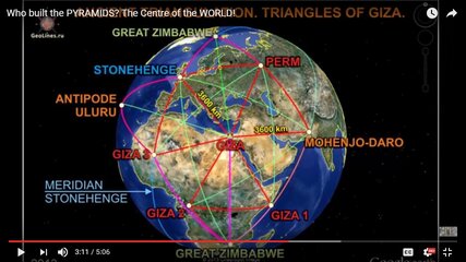
Re: Project Flat Earth
In my experience as a seaman. Marami rami na rin akong karagatan na nalakbay at tinawid ng mga nasakyan kong mga international oceangoing vessels. Natawid ko na ang iba't ibang big bodies of water separating continents gaya ng pacific ocean, atlantic ocean at iba pa. I travelled from EAST to WEST & vice versa. The earth is totally round dude. Speaking of evidences to prove the earth is round, meron kaming ginagamit na mga nautical charts, electronic charts sa barko na ginagamit sa voyage planning. Sample... We Travelled from Asia (Speciically South Korea) to Mexico... From Mexico to panama canal.. Then entered Gibraltar strait then finally Europe (Specifically in Ukraine)... From Ukraine to China passing the Suez canal and Piracy area in Somalia then finally reach the Malacca strait near malaysia and singapore.. Then proceed to China. Kulang nalang is bumalik sa Korea. Go and check the map and see it yourself guys. Hindi yan based on observation, based yan on facts and experiences.
There a lot of resources we can find on the internet. Some FACTS, some LIES to confuse US.
Let's not be blinded easily with these FAKE FACTS...
eto ang totoo at naniniwala ako dito,
")
1) Dahil hindi mo naman pwedeng patunayan na may mga satellite nga sa kalawakan sa pamamagitan ng salita lang. At ang encouragement ko na mag-pakita ng proof ay di ko naman sinasabing dapat ay siya mismo ang kumuha. Yung masasabi nya lang na sa isang tingin pa lang ay kuha ng isang artificial satellite sa kalawakan ay maaari na.
1)... Kaya nga kung may powerful camera naman like radio telescope at least may isa kang makukuhang image ng satellite captured from the ground. Kapag nag-search ka sa kahit anong search engine walang lalabas na image ng satellite kundi yung kinunan na mula sa kalawakan.
2) Hindi pwedeng situated ang mga artificial satellite sa thermosphere kasi "diumano" ayon sa mga scientist ay dyan tumatalbog pabalik ng outerspace yung radiation mula sa araw. Kaya lang ang mga articifial satellite ayon na rin sa mga space agencies ay lampas ng thermosphere (as in lampas lampasan). Samantalang ang ionosphere situated mas mababa sa thermosphere.
...
1) Again, hindi naman mapapatunayan ng salita lang na may mga artificial setellites na nago-orbit around earth e. Syempre actual footage.
...
eto TS copy/paste ko uli,
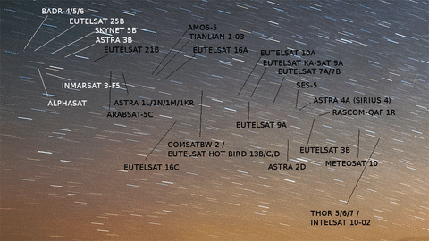
With a consumer grade camera anyone can document the locations of satellites.
Here is a list of such satellites (may not be complete). You can point a camera at the celestial equator and take a long exposure photo. The stars will form 'star trails' but there will be a few dots that remain fixed. Those are geostationary satellites.
For example:
There's actually a cool demonstration in that .gif. You will notice that most of the stationary dots in the frame form a line. This is the celestial equator. There are a couple, however, orbiting off that line. These are satellites orbiting at some inclination to the equator, and therefore are not
geostationary, but instead are
geosynchronous. They orbit in sync with a given longitudinal line on the moving surface of the earth, but they move north-to-south over the course of each orbit. Several examples are visible in this image. Find Alphasat, in white text on the left and positioned below Eutelsat 25B. Unlike the conga line of the other satellites, Alphasat is A) not in line, and B) obviously moves upwards (north) across the frame. Move to the right a little bit and find Eutelsat 16C, black text. It moves down (south) but not very much, you have to look closely. Find Astra 2D, black text right of center, about 1/3 in from the right side of the frame. This one makes a visible shift downward (south) in the frame. There's another, unidentified satellite that begins near the "0" at the end of the Meteostat 10 label. It also moves south over the course of the gif.
1)...
3) Tungkol sa electromagnetic wave, eto naman ang ishe-share kong knowledge dyan.
Yung tinatawag na HETERODYNING.. Yan yung paggamit ng dalawa o higit pang radio
frequencies para makapag-hybrid ng panibagong frequency. Yan yung ginagamit sa radar ng
mga weather station, wifi, mobile phone signal, satellite disc (kaya nakakapagbroadcast via
satellite) Hindi kailangan ng line of sight dyan kasi nga pwedeng mag-hybrid ng frequency.
Hindi kailangan ng artificial satellite sa outerspace para dyan, ang ginagawa lang ay yung
tinatawag na ELECTROMAGNETIC WAVE PROPAGATION (nagtatanim ka ng electromagnetic
wave sa ionosphere then tutubo sya (magbabounce) from ionosphere to the "line of sight"
(pero hindi direct line of sight dahil pwede naman syang tirahin ng panibagong radio
frequency para mag-hybrid into other radio wave na pwede nang masagap ng kung anu
anong reciever. I-example na lang natin ang AM/FM stations, kapag wala sa line of sight ang
communication ng radio frequencies makakarinig ka ng radio statics, may mga stations na
nagooverlap yung dalawang frequency kaya pareho mong naririnig yung broadcast nung
dalawang station.
4) ... sa pamamagitan ng
HETERODYNING namamanipulate nila ang weather system nila. Hindi kailangan ng satellites,
tore lang ng mga radio disc ang ginagamit.
.
1. So base sa share mong "knowledge" tungkol sa EMW, etong bang sample video sa baba(at iba pang monitoring ng bagyo) hindi kuha mula sa satellites, kundi produkto din ng sinasabi mong HETERODYNING at ELECTROMAGNETIC WAVE PROPAGATION?
2. At, narinig mo na ba yung Intersatellite Optical Heterodyne Communication Systems?
 yes you are right no need to argue. actually you are wasting our time. now i understand mahilig ka nga sa conspiracy theory. i suggest you also read the book "The Biggest Secret" by David Icke.
  isama mo na din ang book ni Erich Von Daniken. you are deceived by these conspiracy theorists. just plain simple. credentials. if i am sick where do i go? doctor or albularyo? if i want repair of my cp, technician or basurero? that is why i am asking who is this eric dubay? and you discredit our very own DOST? hahaha. i bet you havent heard of that satellite dont you?
  walang sustansya

 susuportahan kita dyan go lang ng go